

You can find on this page the Phoenix zipcodes map to print and to download in PDF. The Phoenix zip code map presents postal codes, address lookup and code list of Phoenix in Arizona - USA.
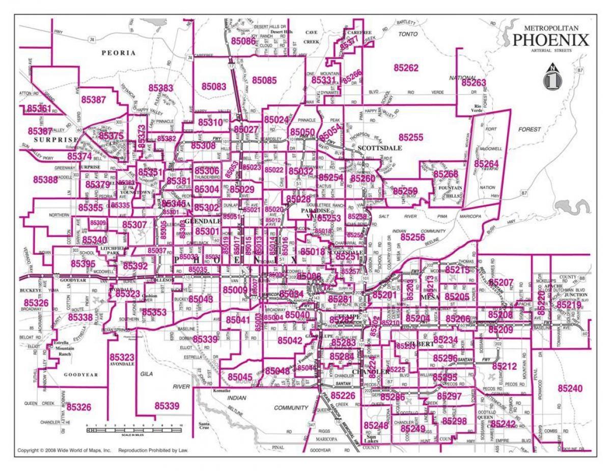
The Phoenix postcodes map shows all the zip codes of Phoenix. This zip code map of Phoenix will allow you to easily find postal codes and address lookup of Phoenix in Arizona - USA. The Phoenix postcode map is downloadable in PDF, printable and free.
Phoenix residents might know that postcodes and city limits do not always line up. There are parts of postcodes that extend into other cities. Postcode 85004 is located in central Arizona and covers a slightly less than average land area compared to other postcodes in the United States as its mentioned in Phoenix postcodes map. It also has a slightly higher than average population density. The people living in postcode 85004 are primarily white. The number of young adults is extremely large while the number of people in their late 20s to early 40s is extremely large. There are also an extremely large number of single adults and an extremely small number of families. The percentage of children under 18 living in the 85004 postcode is extremely small compared to other areas of the country.
Phoenix postcodes as you can see in Phoenix postcodes map are as follows: 85001 85002 85003 85004 85005 85006 85007 85008 85009 85010 85011 85012 85013 85014 85015 85016 85017 85018 85019 85020 85021 85022 85023 85024 85025 85026 85027 85028 85029 85030 85031 85032 85033 85034 85035 85036 85037 85038 85039 85040 85041 85042 85043 85044 85045 85046 85048 85050 85051 85053 85054 85060 85061 85062 85063 85064 85065 85066 85067 85068 85069 85070 85071 85072 85073 85074 85075 85076 85078 85079 85080 85082 85083 85085 85086 85097 85098.
Postcode 85003 is located in the state of Arizona in the Phoenix metro area. Postcode 85003 is primarily located in Maricopa County as its shown in Phoenix postcodes map. The official US Postal Service name for 85003 is Phoenix, Arizona. Portions of postcode 85003 are contained within or border the city limits of Phoenix, AZ. The area code for postcode 85003 is 602. 85003 can be classified socioeconically as a Lower Middle Class class zipcode in comparison to other postcodes in Arizona. The current unemployment level in 85003 is 7.3% which is higher than the current county unemployment level of 4.9% and is higher than the current state unemployment at 7.0% and higher than the current national unemployment rate at 6.0%.